An Overview of the Project and Its Scope
The Toodyay Road Upgrade between Dryandra Road and Toodyay town is a major infrastructure initiative funded jointly by the Australian and Western Australian Governments to the tune of approximately $80 + million, with $64 million contributed federally through the Regional Road Safety Program.
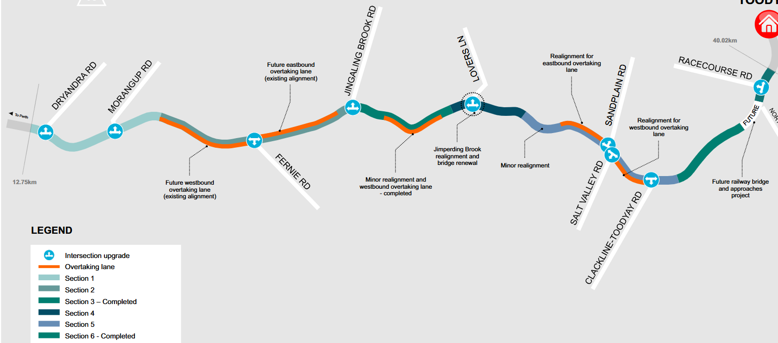
Stretching about 27 kilometres, this upgrade addresses a dangerous corridor with a long history of crashes — 81 crashes from 2011 to 2021, including 30 fatalities or serious injuries. Traffic volumes are expected to grow, compounding the risk.
The project features extensive works including:
- Realignment of hazardous curves
- Addition of five passing lanes to allow safe overtaking
- Intersection upgrades with turning pockets and improved sightlines
- Road widening with 4.5 m lanes and 1 m sealed shoulders each side
- Replacement of the 85-year-old Jimperding Brook bridge with a single-span structure
These interventions are designed to create a safer, more forgiving road environment, improve freight flow, ease congestion, and support regional connectivity.
Project History and Timeline
The project was first conceived in the mid-2010s, with community and stakeholder engagement commencing in 2017. Initial works included two stand-alone sections completed between 2022 and 2024 – Jingaling Brook and Clackline-Toodyay to Toodyay townsite.
In July 2025, Main Roads WA issued a tender to consolidate the remaining sections into a single contract, to be finalised in winter 2025 with major site works commencing in spring 2025.
Construction is expected to span approximately three years, concluding by mid-2027, with multiple crews working simultaneously along the route.
Construction Management and Community Engagement
Main Roads WA has committed to keeping Toodyay Road open in both directions for as long as possible during construction, minimising detours and contraflow.
Local residents and stakeholders are kept informed through letter drops, signage, and ongoing liaison via the Community Reference Group (CRG), which has met formally six times since 2017 and remains engaged.
The project team remains open to ongoing discussions and feedback from the community during construction.
Environmental Considerations and Offsets
Vegetation clearing is unavoidable but has been reduced from an approved 54.87 hectares to around 48 hectares through design modifications such as:
- Reducing cut depth at Sandplain and Salt Valley intersections by 50% (from 12 m to 6 m), preserving mature wandoo trees and habitat for 85 black cockatoo breeding trees
- Retaining a mature wandoo tree at Fernie Road
- Narrowing construction access corridors from 5 m to 3 m
Revegetation efforts include:
- Planting 52 hectares of native vegetation along the corridor
- Sourcing 13,800 seedlings representing 55 species from six regional nurseries
- Translocating 90 grass trees and 20 macrozamia palms
- Installing 188 artificial black cockatoo nesting hollows managed by the Department of Biodiversity, Conservation and Attractions (DBCA)
- Expanding the Clackline Nature Reserve by 196 hectares—almost four times the amount of vegetation removed—which will be conserved in perpetuity
Design Challenges and Solutions
The project balances modern safety standards — such as minimum 4.5 m lanes, 1 m sealed shoulders, and 3 m clear zones — with the constraints of undulating terrain and ecological sensitivity.
The Sandplain and Salt Valley intersections required road realignment and cuts to improve poor sight distances on hill crests, necessitating significant earthworks.
The project underwent a rigorous options analysis, ultimately selecting the most substantial upgrade package (seal widening to 11 m with full safety improvements), as it offers a 20% increase in travel efficiency and maximizes crash reduction.
Community Concerns and Advocacy
Despite these efforts, groups like Safe and Scenic Toodyay Roads (SASTR) have voiced strong concerns, citing the scale of earthworks and vegetation clearing as excessive, arguing that safer, less impactful alternatives such as sealed shoulders and rumble strips could suffice.
Their parliamentary petition attracted over 2,000 signatures and criticized the consultation process for lacking transparency and adequate community input on final designs.
Alternative Routes and Regional Connectivity
Many locals now rely on the recently fully sealed Fernie Road, which branches off Toodyay Road, providing a smoother and safer connection to surrounding rural communities. Along with Salt Valley Road, the newly Shire sealed Chitty Road, and the nearby Clackline Road, these routes form important alternative corridors that head directly from Morangup into Bakers Hill and Northam.
The sealing of these roads has significantly improved travel reliability, especially during wet weather, and offers residents and freight operators practical bypasses to busier or more accident-prone sections of Toodyay Road. This network not only supports local farming, tourism, and freight but also strengthens regional ties by enhancing access to Bakers Hill’s services and amenities, as well as the employment hubs in Northam.
Importantly, these routes also handle significant heavy vehicle traffic servicing the Hoddys Well landfill, a key regional waste facility. Refuse trucks, including those hauling medical and commercial waste, frequently use Fernie Road, Salt Valley Road, and Clackline Road to access the landfill and regional work sites. Planned intersection and road upgrades along these corridors aim to enhance safety and efficiency for all road users on these vital freight and commuter routes.
Impact on Morangup and Local Residents
For those of us in Morangup, Toodyay Road is far more than just a strip of asphalt. It’s the lifeline we rely on daily—connecting us to schools, shops, workplaces, and the wider region. It’s a familiar route woven into the fabric of our community’s identity, economy, and everyday lives.
While we naturally hold a deep affection for the road’s scenic, rural charm—the tree-lined stretches and tranquil surrounds—we also recognise and appreciate the vital importance of the upgrade. Wider shoulders, overtaking lanes, and improved intersections will enhance safety for everyone who travels this corridor, reducing the risk of serious crashes and making journeys smoother and more reliable.
During the coming construction phase, residents can expect some inevitable disruptions, including stop-go traffic, occasional detours, and increased heavy vehicle movements. The project team is committed to clear and timely communication, ensuring that the community receives advance notice of any works that might impact daily travel.
This balance—between preserving the character we cherish and embracing improvements that protect lives—is something we, as a community, approach with understanding and care. The upgrades represent a significant step toward safer, better motoring on a road we all hold dear.
Looking Ahead
This upgrade is a key piece of a broader strategy to improve Wheatbelt connectivity and regional safety.
The project complements future developments such as the planned EastLink WA controlled-access highway connecting Perth to Northam.
Construction progress can be tracked via the official Main Roads WA webpage: https://www.mainroads.wa.gov.au/projects-initiatives/all-projects/regional/toodyay-road/.
For enquiries, the public can call 138 138 or email enquiries@mainroads.wa.gov.au.