Rural Road Numbering (Rural Property Address Numbers) is the system used across regional Western Australia to identify property entrances accurately for emergency services, postal delivery and navigation. In Morangup and the wider Shire of Toodyay, understanding how this system works can make a real difference during bushfires, medical emergencies and other time-critical events.
The example below shows how a single, large rural property can have more than one Rural Property Address Number because it has more than one usable entrance on different roads, while still remaining a single legal Lot on a Deposited Plan. This is common in areas like Morangup where properties can be hundreds or thousands of acres, and may border roads such as Toodyay Road and Morangup Road at the same time.
✅ Example: How a Single Property Can Have Multiple Rural Property Numbers
(Morangup-styled scenario with current WA rural addressing rules)
Consider a large rural holding:
Lot 10000 on Deposited Plan 123456
Size: 1,000 Hectares
This is the legal land parcel.
The LOT number never changes, unless the land is subdivided or amalgamated.
Now let’s look at the access points, because this determines the rural addressing.
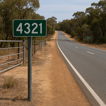
🚪 Entrance 1 — Gate on Toodyay Road
The property has a main driveway on:
4321 Toodyay Road
This gate receives its own Rural Property Address Number because:
- it is a usable, trafficable entrance
- it connects directly to Toodyay Road (a higher-order arterial road)
- it provides emergency crews with fast access to part of the property
- it is the preferred access for some types of incidents (e.g., medical)
This becomes 4321 Toodyay Road in the State Address Database.
🚪 Entrance 2 — Gate on Morangup Road
The same property also has a separate driveway on:
1000 Morangup Road
This entrance sits on a different road, so it receives its own second Rural Property Address Number.
This is common for large acreage lots that:
- border two or more roads
- have long internal distances
- have machinery sheds or secondary dwellings closer to one gate than the other
- need safe access from more than one direction during a bushfire
This becomes 1000 Morangup Road.
🏠 Secondary Buildings on the Same Lot
A 1,000-hectare property may include:
- a main residence
- a manager’s residence
- caretaker quarters
- shearing/farmhand accommodation
- operational sheds
- machinery workshops
- livestock handling areas
- older secondary homesteads
These buildings may be hundreds of metres or several kilometres apart.
Why this matters:
Different buildings may be best reached from different gates.
Example scenarios:
- The shearing shed is closest to the Morangup Road entrance
- The main family home is closest to the Toodyay Road entrance
- Livestock emergencies may require access from the “back gate”
- Ambulances may need the fastest route to the manager’s quarters
- Fire crews may need to enter from the upwind side of a fire
Each usable, trafficable entrance on a different road can be allocated its own rural address.
But the LOT number remains a single identifier
(Lot 10000 DP 123456).
🔥 Why Multiple Rural Numbers Improve Emergency Response
Emergency services rely on Rural Property Address Numbers, not Lot numbers.
This system allows:
✔ Accurate routing
Each rural number corresponds to a specific gate, not the entire property.
✔ Choosing the safest access point
Crews can pick:
- the upwind side in a bushfire
- the closest gate for medical calls
- the safest route when roads are blocked
- the right entrance for livestock or shed fires
✔ Reduced response times
No need to search multiple driveways on a massive property.
✔ Clear mapping
Both numbers appear in:
- DFES dispatch
- St John GPS
- Police navigation systems
- EmergencyWA geocoding
✔ Avoiding dangerous delays
Especially when:
- smoke obscures visibility
- driveways are long
- trees are down
- loop roads are blocked
- one entrance becomes unsafe due to fire behaviour
🟢 Summary: How It Works
This 1,000-hectare property ends up with:
Legal Identifier:
Lot 10000 on Deposited Plan 123456
(does not change)
Emergency & Postal Identifiers:
4321 Toodyay Road
1000 Morangup Road
These are two separate rural numbers
for two different road entrances,
all leading to buildings on one single lot.
Why This Matters for Morangup & the Shire of Toodyay
Morangup and the eastern hills region have long, heavily vegetated roads, dead ends, loop roads and properties that span large distances between buildings. In a bushfire, storm, medical event or serious accident, Rural Property Address Numbers help DFES, St John, WA Police and SES reach the correct gate, on the correct road, in the shortest possible time.
For residents, farm managers and property owners, understanding how rural numbering works supports better bushfire planning, clearer directions to Triple Zero (000), and more reliable information sharing on local platforms like Emergency WA, Bushfire.io and the Morangup Residents Group.
If your property borders two roads, or if you have separate entrances for workers’ quarters, shearing sheds or agricultural operations, speak with the Shire of Toodyay about whether additional Rural Property Address Numbers are appropriate for your site. Getting this right before an emergency helps everyone on the day.